Earthquakes in Japan: The Complete Guide for Visitors and Residents
Japan is one of the easiest countries in the world to fall in love with. The trains run to the second. The cities are orderly. The buildings are engineered with a quiet, obsessive awareness of natural hazard. And underneath all of it, the ground moves.
Japan sits where several tectonic plates meet. Earthquakes happen offshore along enormous subduction trenches, and inland along faults that run directly beneath towns and cities. The result is a country where earthquakes are not an interruption to normal life — they are one of the conditions of it, and Japan has spent generations building a society around that fact.
For a tourist, that can sound alarming. For someone moving here, it raises a harder question: what does it actually mean to live in an earthquake country?
The honest answer sits between the two stories people usually tell. "Japan is dangerous" is wrong. "Japan is completely prepared, so don't worry about it" is also wrong — and, as the July 2026 Kumamoto earthquake demonstrated with painful clarity, it is the more expensive mistake. A modern Tokyo apartment, a century-old wooden house in Kyoto, a shopping mall in Kyushu, a Shinkansen at 285 km/h and a beach on the Pacific coast are five completely different earthquake risks. Understanding the difference, and knowing what your body should do in the first three seconds, is the single most useful thing a foreigner can learn about this country.
This guide is written to be that briefing. Every hard number is sourced to the Japan Meteorological Agency, MLIT, the Fire and Disaster Management Agency, the Cabinet Office, the Geospatial Information Authority, or Japan's Earthquake Research Committee. Where figures are provisional, we say so. For what is shaking across Japan right now, keep our live earthquake tracker open alongside this page — it uses the same Shindo colour bands you will learn below.
Read this part even if you read nothing else
Pro Tip
The five rules that cover almost every situation:
-
1
Protect your head first, move second.
Most earthquake injuries in Japan come from falling objects and furniture, not collapsing buildings.
-
2
Do not run outside while it is still shaking.
Glass, roof tiles, signage and air-conditioning units come off buildings. The inside of a modern Japanese building is usually the safer place.
-
3
Strong or long shaking near the coast means tsunami.
Do not wait for the alert, do not go to look, do not return for belongings.
-
4
The first earthquake is not necessarily the biggest.
In 2016, Kumamoto's second Shindo 7 arrived 28 hours after the first.
-
5
Follow staff.
Japanese hotel, station, mall and railway staff are drilled for this. They are usually the best-informed people in the room.
For live intensity around Japan right now — the same Shindo colour bands used throughout this guide — open the earthquake tracker.
Part 1 — The Honest Picture
How often does Japan actually shake?
Roughly 2,000 earthquakes a year are strong enough to be felt somewhere in Japan — about five a day. Around 50 a year reach Shindo 4, the level at which hanging objects swing and people are startled. Most of those never make the news outside the affected prefecture.
Scaled up, Japan and its surrounding waters absorb about 10% of the world's earthquakes of magnitude 5.0 and above, in a country occupying a fraction of a percent of the planet's surface.
How often does Japan actually shake?
Japan occupies a small slice of the planet but absorbs roughly a tenth of its moderate-to-large earthquakes. Most are never felt as anything more than a rattle.
M8.0 and above
M7.0 – 7.9
M6.0 – 6.9
M5.0 – 5.9
~2,000
felt quakes (Shindo 1+) per year — about 5 a day
~50
reach Shindo 4 or above in a typical year
~10%
of the world's M5.0+ earthquakes happen in and around Japan
Bars use a logarithmic scale — each step right is roughly ten times more earthquakes.
Source: Japan Meteorological Agency FAQ「地震について」— Japan and vicinity averages from JMA hypocentre data 2014–2023; world averages from USGS data (M8.0+ 1900–2021, others 1990–2021). Felt-earthquake and Shindo 4+ counts from JMA.
Read that chart the right way. The M8-and-above line is the one that produces national catastrophes, and it runs at roughly once a decade. The M7 line — the Kobe, Kumamoto and Noto class — runs at about once a year, and those are the earthquakes most likely to affect an individual person's life, because they happen inland, close to where people actually live.
Why Japan shakes: three different machines
Japan's seismic environment is genuinely complicated, because earthquakes here are produced by several different mechanisms that behave differently and require different responses.
1. Subduction-zone earthquakes
Oceanic plates are being forced beneath the Japanese archipelago at several centimetres a year. When the locked interface between plates finally releases, it can produce the largest earthquakes on Earth. The key structures are the Japan Trench and Kuril Trench to the northeast, the Sagami Trough off Kanto, and the Nankai Trough running along the Pacific side of southwestern Japan.
These are the earthquakes that generate major tsunamis. The 2011 Tōhoku disaster was one.
2. Crustal (inland) earthquakes
Japan is laced with active faults that run beneath populated land. These earthquakes are much smaller in magnitude — typically M6.5 to M7.5 — but they occur at shallow depth, directly under towns. Kobe in 1995, Kumamoto in 2016, Noto in 2024 and Kumamoto again in 2026 were all crustal earthquakes.
They rarely produce large ocean-wide tsunamis. They are, however, disproportionately deadly, because the energy arrives directly underneath buildings rather than travelling a hundred kilometres from an offshore epicentre. This is the category most people underestimate.
3. Offshore earthquakes near the coast
Between the two: earthquakes beneath coastal seas and bays. These can shake hard and still generate local tsunamis very quickly — the 2024 Noto earthquake produced tsunami waves along the Sea of Japan coast within minutes.
The two numbers: magnitude and Shindo
The first thing that confuses foreigners watching Japanese earthquake coverage is that Japan reports two numbers. You will hear something like "magnitude 7.1, maximum intensity 7." These are not the same measurement and they are not in conflict.
Magnitude describes the size of the earthquake at its source — one number for the whole event.
Shindo (震度), the JMA Seismic Intensity Scale, describes how hard the ground shook where you are standing. One earthquake produces hundreds of different Shindo readings across the country. It runs on a 10-step scale: 0, 1, 2, 3, 4, 5-lower, 5-upper, 6-lower, 6-upper, and 7.
The Shindo scale: what each level actually feels like
Japan reports earthquakes on a 10-step seismic intensity scale — 0, 1, 2, 3, 4, 5-lower, 5-upper, 6-lower, 6-upper and 7.
Instruments record it. Nobody feels it.
A few people sitting quietly indoors notice it.
Many people indoors feel it; hanging lamps sway slightly.
Felt by most people indoors. Dishes rattle.
Startling. Hanging objects swing hard, unstable items topple. Sleepers wake.
Alarming. Unsecured furniture may shift; unfastened objects fall.
Hard to walk without holding something. Unsecured furniture can topple.
Difficult to stay standing. Wall tiles and windows break. Weaker houses can lean or collapse.
Impossible to stand or move without crawling. Many unreinforced buildings collapse.
You are thrown by the shaking. Even seismically sound buildings can lean or fail.
Shindo is measured where you are standing, not at the epicentre. One earthquake produces many different Shindo readings across the country — which is why Japanese broadcasters lead with intensity, not magnitude. Colours match the bands on our live earthquake tracker.
Source: Japan Meteorological Agency, Explanation table of the JMA Seismic Intensity Scale. Descriptions are simplified; JMA notes that real-world effects vary with building type and ground conditions. Colour bands aligned with the Japanist earthquake tracker.
Japanese broadcasters lead with Shindo, not magnitude, and you should too. A magnitude 7 offshore earthquake 200 km away might give you Shindo 3 — mildly interesting. A magnitude 6.5 earthquake eight kilometres beneath your neighbourhood can give you Shindo 6-upper — potentially life-changing. The colour bands above are the same ones on our live earthquake tracker — once you learn them here, you can read the map without translating.
There is also a third scale you will increasingly hear on Japanese television: long-period ground motion intensity (長周期地震動階級), a 1–4 scale added in 2023 that describes the slow, rolling sway that affects tall buildings. If you live above the tenth floor of a high-rise, this is your number — it is why furniture in Osaka skyscrapers can slide across the floor during an earthquake centred hundreds of kilometres away.
Part 2 — Five Earthquakes That Made Modern Japan
Almost every element of Japanese disaster policy — building codes, warning systems, shelter standards, railway automation — can be traced to a specific earthquake that exposed a specific failure.
Five earthquakes that rewrote Japanese disaster policy
Bars show total deaths, including disaster-related deaths certified after the event. Every one of these reached the maximum Shindo 7.
Inland fault beneath a dense city
Subduction megaquake + tsunami
Two Shindo 7 shocks, 28 hours apart
Sea of Japan coast; 70% died after the quake
Shallow strike-slip; figures still provisional
Magnitude and death toll are only loosely related. The 2026 Kumamoto earthquake released roughly the same energy as the 1995 Kobe earthquake, but killed a small fraction as many people — the difference is where it struck, and what was standing there.
Sources: FDMA damage reports (Tōhoku, as of 1 Mar 2026: 19,787 dead + 2,549 missing; Kumamoto 2026, as of 5 Aug 2026); Ishikawa Prefecture / national tallies for Noto (228 direct + 522 disaster-related, Aug 2026); Cabinet Office and JMA records for Kobe 1995 and Kumamoto 2016. 2026 figures are provisional and continue to be revised.
Click any marker for the short version of what that earthquake taught Japan. For what is shaking right now, switch to the live tracker.
1995 — The Great Hanshin-Awaji Earthquake (Kobe)
On 17 January 1995, a magnitude 7.3 crustal earthquake struck beneath the Kobe area at 5:46 a.m. It reached Shindo 7 and killed more than 6,400 people. Over 100,000 buildings were completely destroyed, and fires burned through dense wooden neighbourhoods that fire engines could not reach because the roads were blocked with rubble.
Kobe demolished the comfortable assumption that only magnitude-9 monsters were dangerous. A shallow M7.3 under a city is a national catastrophe. It triggered Japan's seismic-retrofit programme, transformed emergency-response coordination, and created the modern volunteer disaster-relief culture.
2011 — The Great East Japan Earthquake (Tōhoku)
At 2:46 p.m. on 11 March 2011, a magnitude 9.0 earthquake struck off northeastern Japan — the largest ever recorded in the country. JMA recorded Shindo 7 in Kurihara, Miyagi, with Shindo 6 and below observed from Hokkaido to Kyushu.
The earthquake itself killed relatively few people. The tsunami killed almost everyone. More than 90% of victims drowned. As of March 2026, the official tally stands at 19,787 dead and 2,549 missing, with 122,204 homes completely destroyed.
Tōhoku rewrote Japan's tsunami doctrine. The old model — check the warning, then decide — was replaced with a blunt instruction that is now taught to every schoolchild on the coast: if the shaking is strong or long, run uphill immediately.
2016 — The Kumamoto Earthquakes
On 14 April 2016, a magnitude 6.5 earthquake hit Kumamoto Prefecture and reached Shindo 7. Emergency services deployed, residents returned to check their homes, and many slept in damaged houses.
Twenty-eight hours later, a magnitude 7.3 earthquake hit the same area and also reached Shindo 7. Buildings that had survived the first shock collapsed in the second, in some cases with people inside who had gone home.
Japan does not use the words "foreshock" and "aftershock" as casually as it used to. JMA now warns explicitly that shaking of similar intensity can recur, particularly in the first week. The 2016 sequence also produced the single most important dataset in Japanese housing safety, which we come to in Part 6.
2024 — The Noto Peninsula Earthquake
At 4:10 p.m. on New Year's Day 2024, a magnitude 7.6 earthquake struck the Noto Peninsula in Ishikawa Prefecture. It reached Shindo 7, generated a tsunami along the Sea of Japan coast within minutes, triggered landslides that severed the peninsula's only road access, and started a fire in Wajima that burned about 240 buildings.
Noto broke two more assumptions. First, that Japan's serious earthquake risk lives on the Pacific side. Second — and far more important — the assumption that the earthquake is the dangerous part.
The 2024 Noto earthquake killed most of its victims after the shaking stopped
Ishikawa Prefecture has certified 522 disaster-related deaths against 228 direct deaths — a total of 750, as of August 2026.
More than two-thirds of the people who died did not die during the earthquake.
Disaster-related deaths (saigai kanren-shi, 災害関連死) are officially certified deaths caused by the aftermath rather than the shaking itself: hypothermia in unheated shelters, dehydration, untreated chronic illness, infection, and the physical toll of weeks without water, heating or medical access. Preparedness that keeps you warm, hydrated, medicated and connected is not a lesser priority than surviving the shaking. It is the larger one.
Sources: Ishikawa Prefecture disaster-related death review panels (via Sankei / Ishikawa TV, June–August 2026); Cabinet Office 令和7年版防災白書; FDMA. Certification is ongoing and totals may rise further.
This is, for anyone actually living in Japan, the most consequential chart in this article. Two hundred and twenty-eight people died in the earthquake. Five hundred and twenty-two died afterwards — of hypothermia in unheated evacuation centres on a January peninsula, of dehydration, of chronic conditions that went untreated when hospitals and pharmacies were cut off, of infections that spread in crowded shelters, of the slow physical collapse that comes from weeks without running water.
Your emergency kit is not really about the ninety seconds of shaking. It is about the three weeks afterwards.
2026 — The Kumamoto Earthquake (令和8年熊本地震)
If you are reading this guide in 2026, the subject cannot be treated as history.
At 4:27 p.m. on Tuesday 28 July 2026, a magnitude 7.1 earthquake struck the Kumamoto region at a depth of about 16 km. JMA recorded Shindo 7 in Uki City and Hikawa Town, Shindo 6-upper in Kumamoto City, Yatsushiro, Uto, Misato and Mashiki, and shaking down to Shindo 1 as far away as the Hokuriku region. JMA named the sequence the 2026 Kumamoto Earthquake.
| Detail | Value |
|---|---|
| Time | 28 July 2026, 16:27 JST |
| Magnitude | Mj 7.1 (Mw 6.8) |
| Depth | approx. 16 km (provisional) |
| Mechanism | Strike-slip, crustal — near the Futagawa–Hinagu fault zone |
| Estimated rupture length | approx. 30 km |
| Maximum Shindo | 7 — Uki City, Hikawa Town |
| Long-period ground motion | Class 4 (maximum) in Kumamoto |
| Tsunami advisory | Ariake and Yatsushiro Seas, issued 16:29, lifted 18:10 |
| Ground deformation | GEONET station "Senchō" moved approx. 87 cm northeast and subsided approx. 32 cm |
The human toll, as reported by the Fire and Disaster Management Agency on 5 August 2026 and still provisional: 38 dead, 18 seriously and 109 slightly injured, 699 homes completely destroyed, 1,045 half-destroyed and 6,076 partially damaged. At the peak, Kumamoto Prefecture opened 465 evacuation centres sheltering nearly 10,000 people.
What the 2026 earthquake teaches that the others did not
Two of the deadliest incidents had nothing to do with houses collapsing.
A shopping mall. At about 5:50 p.m., roughly eighty minutes after the earthquake, an explosion occurred at Aeon Mall Kumamoto in Kashima Town. Part of the second floor collapsed, trapping people inside; a gas leak was reported by officials at the scene. Aeon confirmed seven deaths and 26 injuries. The mall had been evacuated and staff had swept the building visually — and it was still not over.
An industrial chimney. At the Nippon Paper mill in Yatsushiro, an 80-metre heavy-oil boiler chimney snapped near its midpoint and fell onto a two-storey building. Eleven workers were trapped; nine died. The chimney had been installed in 1970 and reinforced after the 2016 earthquake.
Meanwhile the Kyushu Shinkansen recorded more than 200 points of damage including broken rail, expressway bridges suffered girder displacement, and MLIT temporarily lowered landslide-warning thresholds across the affected municipalities to 70–80% of normal, because shaken slopes fail in rain that would ordinarily be harmless.
The lessons compound:
-
A magnitude 7-class earthquake can produce Shindo 7.
Even far from any famous subduction zone — inland crustal faults are enough.
-
The hazard does not end when the shaking does.
Gas, structural failure, fire and landslides can arrive minutes, hours or days later.
-
Evacuated is not the same as safe.
Confirming a building is empty does not mean the structure has finished failing.
-
Rain after an earthquake is more dangerous than rain before it.
Shaken slopes fail in rainfall that would ordinarily be harmless.
-
Tsunami advisories cover inland seas and bays.
Not just open Pacific coastline — Ariake and Yatsushiro Seas proved that in 2026.
And the point that matters most for anyone reading a "is Japan safe?" article: the 2026 Kumamoto earthquake was not the 2016 Kumamoto earthquake. They were separate events in the same broad region, ten years apart. Neither was predicted.
Part 3 — Japan's Warning Systems, and Their Limits
Earthquake Early Warning (緊急地震速報)
You have probably heard it in a film without knowing what it was: the two-tone chime, phones shrieking simultaneously across a train carriage, television programming cut off mid-sentence.
This is Kinkyū Jishin Sokuhō, and the critical thing to understand is that it is not a prediction. The earthquake has already happened. Seismometers near the source detect the fast-travelling P-wave, JMA's systems estimate location, magnitude and expected intensity in seconds, and the warning races ahead of the slower, destructive S-wave to areas further away.
JMA issues a warning when seismic waves are detected at two or more stations and the maximum expected intensity is Shindo 5-lower or above. If Shindo 6-lower or above is expected, it is escalated to an Emergency Warning (特別警報).
Why the warning gives you seconds, not minutes
Fast P-waves reach seismometers first; the destructive S-waves follow more slowly. That head start is the entire warning window — and it shrinks to nothing near the epicentre.
The blind zone is the point. Directly above a shallow inland earthquake — exactly the Kobe, Kumamoto and Noto scenario — the shaking can beat the alert. Never wait for your phone to tell you the ground is moving.
Illustrative model using typical crustal wave speeds (P ≈ 7 km/s, S ≈ 4 km/s) and a representative processing time. JMA states the interval between the warning and strong shaking is "several seconds to at most several tens of seconds," and that people close to the source may be warned only after shaking begins. Predicted intensities carry an error of about ±1 Shindo level.
That chart contains the most misunderstood fact about the system. There is a blind zone. Directly above a shallow inland earthquake — the Kobe, Kumamoto and Noto scenario — the strong shaking can physically arrive before the alert does. JMA is explicit about this: the interval is "several seconds to at most several tens of seconds," people near the source may be warned only after shaking has begun, and predicted intensities carry an error of about ±1 Shindo level.
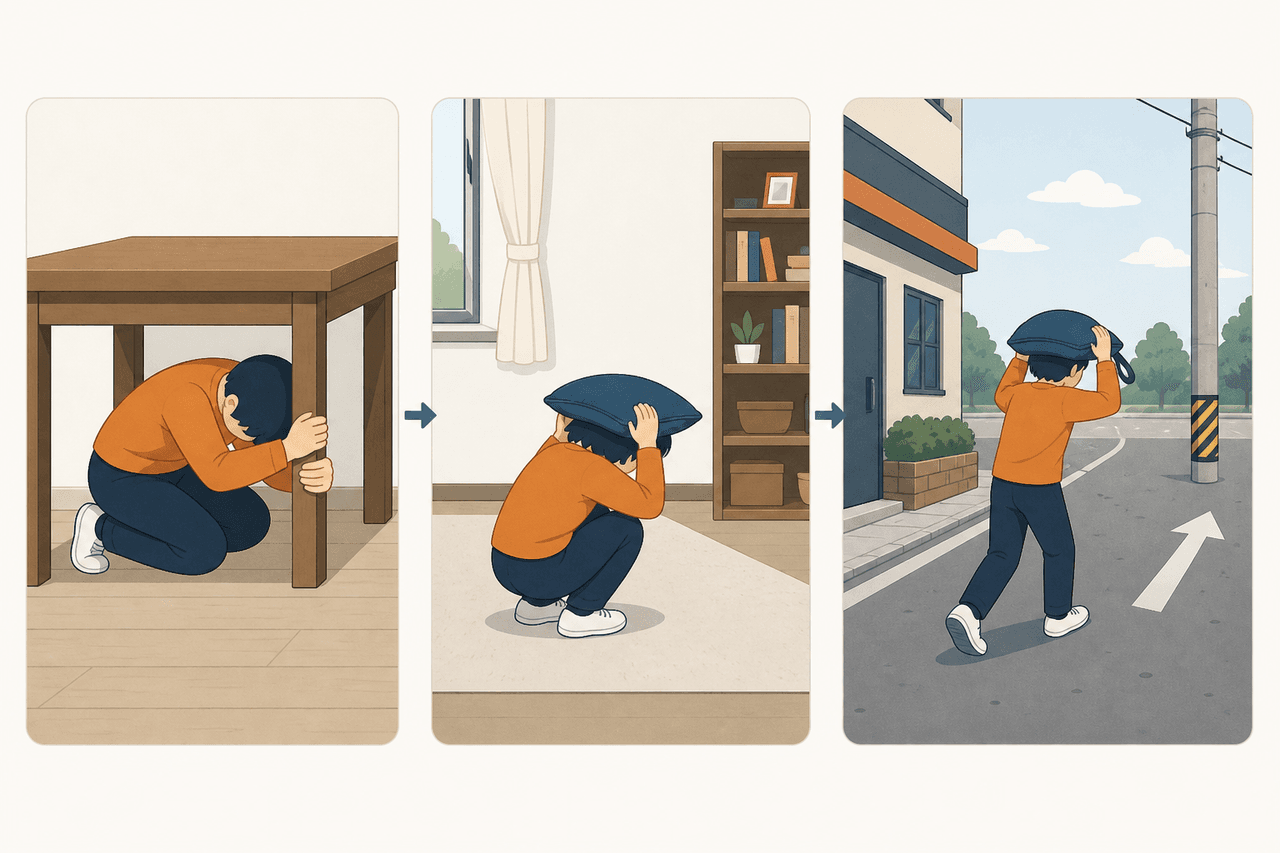
When you hear the alert, do not investigate. Do not check your phone to see how big it is. Protect your head, get low, get away from windows and tall furniture. You can find out what happened afterwards.
Tsunami warnings
After a relevant earthquake, JMA evaluates tsunami potential and aims to issue warnings within roughly two to three minutes. There are three levels, and the number that matters is the expected wave height:
-
Above 3 m
Major Tsunami Warning
大津波警報 · ōtsunami keihō
Evacuate to high ground immediately. Highest level issued by JMA.
-
Up to about 3 m
Tsunami Warning
津波警報 · tsunami keihō
Leave the coast and river mouths at once. Do not drive if you can walk uphill.
-
Up to about 1 m
Tsunami Advisory
津波注意報 · tsunami chūihō
Still lethal in harbours and river mouths. Get out of the water and off the shore.
For very large earthquakes — above roughly magnitude 8 — JMA cannot calculate the true magnitude quickly, and deliberately issues warnings based on conservative assumptions rather than waiting for accuracy. Initial estimates may later be revised upward.
None of which should be read as "I have three minutes to decide." You do not.
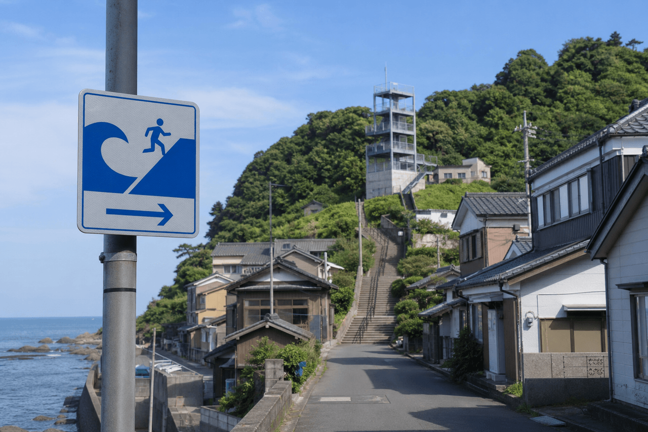
If you are near the coast and the shaking was strong or unusually long, move inland or uphill immediately. Do not wait for the warning. Do not go down to the waterfront to look — this instinct kills people in every tsunami event, everywhere in the world. And remember that tsunami travel up rivers: being a kilometre inland on a riverbank is not safety.
Aftershocks and the hazards that follow
The main shock is not a finish line.
After the 2026 Kumamoto earthquake, 195 felt earthquakes were recorded within about 44 hours, and JMA warned that shaking of similar intensity could recur — with the first week being the critical period.
What follows an earthquake in Japan, in rough order of how often it catches people out:
-
1
Aftershocks
Can equal the main shock. A building that survived once may not survive twice. Watch the live tracker for the sequence, not just the first event.
-
2
Structural weakening you cannot see
Cracked shear walls, damaged connections, compromised chimneys and parapets.
-
3
Landslides
Made far more likely by subsequent rain — this is why MLIT lowers rainfall warning thresholds after major quakes.
-
4
Fire and gas
Ruptured gas lines and damaged wiring. Japanese homes have seismic gas shut-off meters; know where yours is and how to reset it.
-
5
Liquefaction
On reclaimed land and soft river sediment — buildings tilt, utilities shear, manholes rise out of the road.
-
6
Infrastructure loss
Water is usually the slowest utility to return, and its absence is what turns an emergency into a health crisis.
Part 4 — What To Do, Situation by Situation
In a hotel
Get away from windows and anything on wheels or shelves. Take cover under a desk or table; if there is none, get low beside a solid interior wall — not under a hanging light fixture — and cover your head with a pillow or bag.
Do not run into the corridor or outside during the shaking. When it stops: check yourself for injury, put on shoes (broken glass is the most common post-quake injury), locate the stairs, and follow staff instructions. Do not use lifts until they have been confirmed safe.
Japan's official tourist guidance for visitors is explicit that going outside during strong shaking exposes you to falling glass and masonry.
In a restaurant, shop or shopping mall
Move away from shelving, glass display cases, hanging signage and stacked stock. Get low and protect your head. Large retail ceilings are heavy: modern Japanese malls have been retrofitted for this, but ceiling panels and light fittings still fall.
When shaking stops, follow staff — and then keep following instructions once you are outside. The 2026 Aeon Mall Kumamoto explosion happened more than an hour after the earthquake, in a building people had already evacuated. Do not re-enter a large building to retrieve belongings.
On a train or Shinkansen
This is the scenario foreigners fear most and should probably fear least. Japanese railways receive early-warning data directly and apply emergency braking automatically; the Shinkansen has never lost a passenger to earthquake derailment.
Hold a handrail or strap with both hands. Protect your head. Stay in the carriage. Do not open doors and do not climb down onto the track — overhead lines may still be live and adjacent tracks may be in use. Trains can stop between stations for a long time; staff will manage evacuation.
In a lift
Press the buttons for every floor and get out at the first one that opens, if it is safe. Modern Japanese lifts have seismic sensors that stop at the nearest floor automatically. If you are trapped, use the emergency call button and wait — do not try to force doors or climb out.
Outdoors in a city
Protect your head with a bag, and move away from building façades, glass, signage, vending machines, block walls and utility poles. Old concrete block walls (ブロック塀) are a known killer and Japan has been steadily removing them.
Do not follow a crowd reflexively. Look at where they are going. Move toward an open space — a park, a school ground, a wide plaza. Japanese municipalities designate these as evacuation areas (避難場所), which are different from evacuation shelters (避難所) where you actually stay.
Driving
Do not brake hard. Slow gradually, pull to the left, stop, and turn on hazard lights. Listen to the radio. If you must abandon the car, leave the key in it, leave it unlocked, and take your documents — emergency services need to be able to move vehicles.
In an onsen or public bath
An uncomfortable but realistic scenario. Get low, protect your head from falling tiles and light fittings, and be aware that wet stone floors plus violent shaking is a serious fall risk. Grab a towel and a yukata on your way out if you can, but do not delay for modesty. Staff will direct you.
Near the coast, anywhere
Strong or long shaking means move inland and uphill, immediately, on foot. Roads jam. Do not return until authorities lift the warning.
Part 5 — If You Actually Live Here
Tourists need about twenty minutes of preparation. Residents need a weekend, and then an hour a year.
Know your specific neighbourhood
Your municipality publishes a hazard map (ハザードマップ) showing expected shaking intensity, liquefaction risk, landslide zones, tsunami inundation and flood extent for your actual street — usually in the city office and online, often with English versions in areas with large foreign populations. The national portal at hazardmap.gsi.go.jp aggregates them.
Then find and physically walk to each of these, once, in daylight:
-
1
Evacuation area and shelter
Your nearest designated 避難場所 (open refuge) and 避難所 (overnight shelter) — they are often two different places.
-
2
Tsunami evacuation building or tower
Coastal areas only. Note the entrance, and whether it is unlocked at night.
-
3
Hospital and koban
The nearest emergency hospital and police box (交番), where you can report injuries or find someone who is missing.
-
4
Emergency water supply point
Municipal 給水拠点 taps and reservoir points. Water is the slowest utility to come back.
Do this once. It takes an afternoon and it is the difference between deciding under pressure and simply executing.
Secure your home — this is the highest-value hour you will spend
Japanese fire departments consistently find that a large share of earthquake injuries come from furniture and objects, not structural failure. A perfectly engineered building does not help if a wardrobe lands on you. Everything below is available in any home centre for the price of a decent dinner.
-
Anchor tall furniture to walls
L-brackets, or tension poles (突っ張り棒) between the top of the unit and the ceiling.
-
Gel pads under electronics
Adhesive anti-slip pads stop televisions and microwaves from walking off their stands.
-
Latches on kitchen cabinets
Otherwise the contents empty across the floor you will be walking on.
-
Shatter film on large glass
Keeps a broken pane in one sheet instead of across the room.
-
Clear the high shelves
Move heavy and glass objects down — especially above beds and above where you sit.
-
Torch and hard-soled shoes under the bed
Broken glass in the dark is the classic post-quake injury.
-
Nothing heavy on top of a wardrobe
Least of all in a bedroom, and never above a pillow.
Build a kit that reflects the Noto lesson
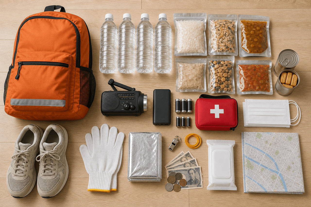
Japanese authorities recommend at least three days of supplies, and seven days in areas that may be cut off — which, as Noto proved, includes any peninsula, valley or island.
The standard list: water (3 litres per person per day), food that needs no cooking, torch, spare batteries, power bank, hand-crank or battery radio, first-aid supplies, work gloves, masks, wet wipes, a whistle, a thermal blanket, and sturdy shoes.
The list that actually saves lives, and that generic kits omit:
-
Prescription medication
At least a week's buffer, plus a photograph of the prescription and your medicine notebook (お薬手帳).
-
Warmth
Noto's disaster-related deaths were substantially a winter-and-hypothermia story. Thermal blankets, disposable heat pads (カイロ), a sleeping bag.
-
Sanitation
Portable toilet bags. Water goes out and stays out — this is not optional, and it is what makes shelters unbearable.
-
Cash in small denominations
Japan is increasingly cashless, and cashless systems die with the power and the network.
-
Identity and paperwork
Copies of your residence card, passport, insurance card and lease — physical and in cloud storage.
-
Personal essentials
Contact lens solution, glasses, spare hearing-aid batteries, baby formula, pet supplies — the things nobody stocks for you.
Communications when the network is overloaded
Voice calls fail first in a disaster; data often survives. Japan operates a disaster message board service (災害用伝言板) through every mobile carrier, and NTT runs 171, a voice message dial service. Both are activated during major disasters and can be practised on the 1st and 15th of each month.
Agree with your family, in advance, on a single check-in method and a single overseas contact who can relay messages. Then do the unglamorous thing: tell people abroad that you are fine, early. In every Japanese disaster, an enormous amount of anxious energy is spent by relatives overseas watching footage of a prefecture nowhere near you.
Install Safety tips, the Japan Tourism Agency's free multilingual app, which pushes earthquake early warnings, tsunami warnings, evacuation guidance and emergency phrases in English and a dozen other languages. NHK WORLD-JAPAN is the other essential — it broadcasts live in English during major events. Our own live earthquake tracker is useful for awareness and context, but for warnings, use JMA and NHK.
Pro Tip
Part 6 — Buildings, Property and the Money Question
This is the section that matters most if you are staying in Japan, and it is the one that real-estate listings are quietest about.
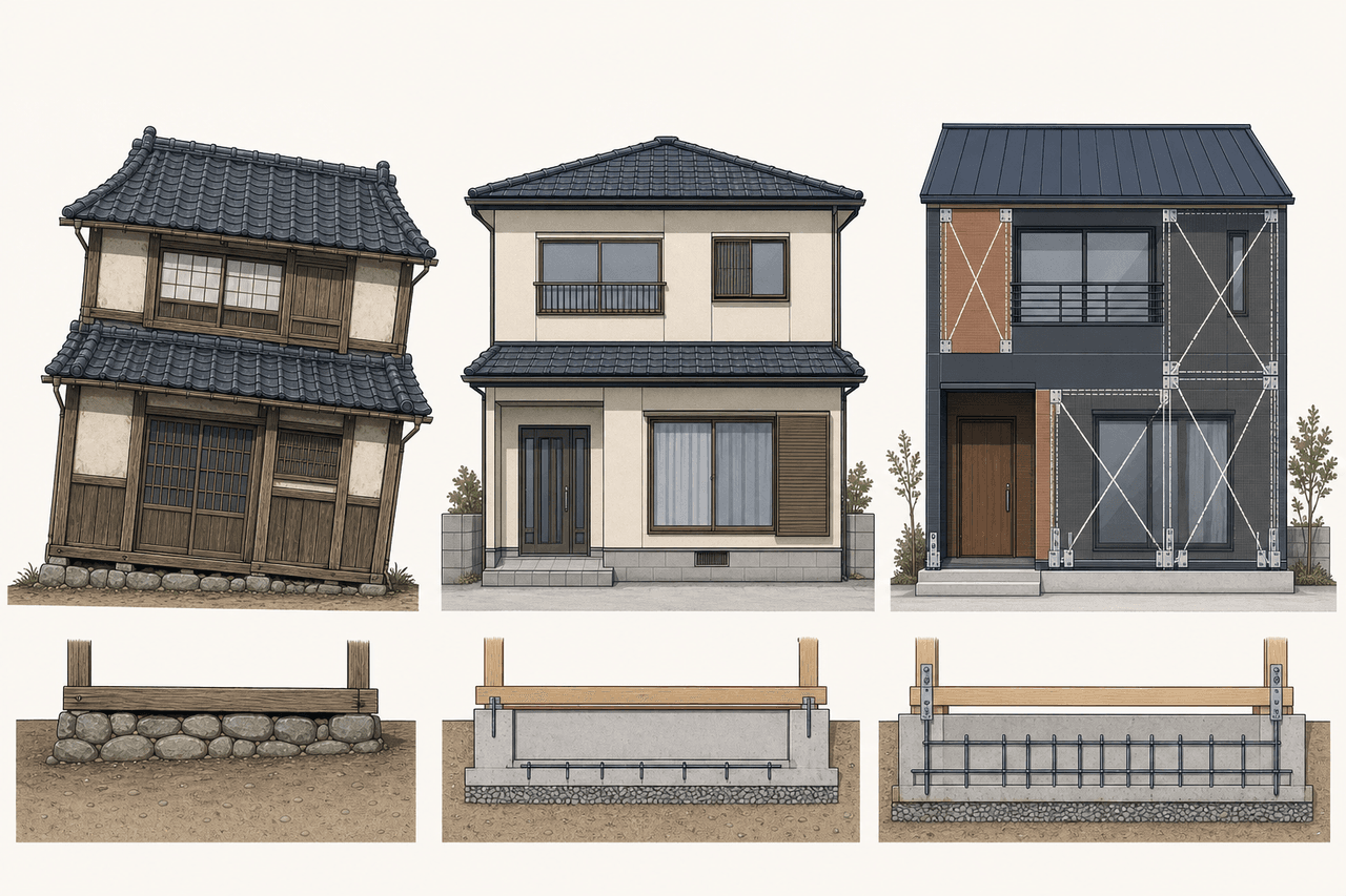
The two dates that matter: 1981 and 2000
Japanese building standards were fundamentally strengthened on 1 June 1981, when the New Earthquake-Resistant Standard (新耐震基準, shin-taishin) came into force. Buildings whose construction confirmation is dated before that are kyū-taishin — old standard. The modern framework is designed so that a building suffers no major damage in moderate earthquakes, and does not collapse under shaking in the Shindo 6-upper to 7 range.
Most guides stop there. They shouldn't, because the 2016 Kumamoto earthquake produced the closest thing Japanese housing has to a controlled experiment.
Government researchers surveyed every wooden house in central Mashiki town — 1,955 of them — after the area was hit by two Shindo 7 shocks in 28 hours. Same town, same ground, same shaking. The only variable was the code they were built under.
The clearest evidence in Japanese housing: Mashiki town, 2016
Government researchers surveyed every wooden house in central Mashiki after the Kumamoto earthquakes. The results are effectively a controlled experiment on Japan’s building codes.
Before June 1981
kyū-taishin (old standard) · 759 houses surveyed
June 1981 – May 2000
shin-taishin (new standard) · 877 houses surveyed
June 2000 onwards
current standard · 319 houses surveyed
Every one of these 1,955 houses stood in the same town and absorbed the same two Shindo 7 shocks within 28 hours. The only meaningful variable was the building code they were built under. Note the middle column: houses built after the famous 1981 reform still collapsed at four times the rate of post-2000 houses. 1981 is a starting point for investigation, not a certificate of safety.
Source: MLIT National Institute for Land and Infrastructure Management and Building Research Institute, committee report on building damage in the 2016 Kumamoto Earthquake (September 2016); survey of 1,955 wooden buildings in central Mashiki conducted with the Architectural Institute of Japan.
A pre-1981 house was thirteen times more likely to collapse than a post-2000 house. But look at the middle column, because that is the one that surprises people: houses built under the celebrated 1981 standard still collapsed at four times the rate of post-2000 houses.
The reason is that a further revision in June 2000 tightened the things the 1981 standard had left vague for wooden houses in particular: mandatory ground surveys, specified foundation design, and — critically — specified metal connectors at structural joints (hold-downs anchoring columns to the foundation). The 1981 code got the walls right. The 2000 revision stopped houses from lifting off their own foundations.
So the working rule for anyone renting or buying:
-
Pre-1981
InvestigateAssume a seismic evaluation and retrofit are required. Price accordingly — the Mashiki data makes this cohort thirteen times more likely to collapse than a post-2000 house.
-
1981–May 2000
VerifyBetter, but not settled. Ask specifically about joints, hold-downs, foundation type and wall balance. MLIT has published a dedicated verification method for exactly this cohort of wooden houses.
-
June 2000 onward
CurrentCurrent standard. Still ask about ground conditions — code compliance does not cancel liquefaction or landslide risk.
The national retrofit gap
Japan has been quietly retrofitting itself for two decades
Share of Japanese dwellings assessed as seismically adequate. The gap is closing, but 5.7 million homes still are not.
55.7M
dwellings in Japan (2023)
5.7M
still seismically insufficient
85% / 96%
conformity: detached houses vs. apartment blocks
MLIT's own assessment is blunt about what that remaining 10% means: those roughly 5.7 million homes are at risk of collapse in shaking comparable to the Noto and Kumamoto earthquakes. Detached houses — the akiya and older family homes foreign buyers are most drawn to — are where nearly all of the gap sits.
Source: MLIT estimates based on the Statistics Bureau Housing and Land Survey (2003, 2008, 2013, 2018, 2023). Government target: substantially eliminate seismically inadequate housing by 2035 (Reiwa 17).
Japan has moved its housing stock from 75% seismic conformity in 2003 to about 90% in 2023, and aims to substantially close the gap by 2035. But roughly 5.7 million dwellings remain seismically inadequate, and MLIT's assessment of them is not subtle: they are at risk of collapse in shaking comparable to Noto or Kumamoto.
Almost all of that gap is in detached houses (85% conformity) rather than apartment blocks (96%) — and disproportionately in rural and ageing regions. Which is to say: it is concentrated in exactly the stock that foreign buyers find most romantic and most affordable.
If you are buying property in Japan
Foreigners face no legal restriction on buying land or buildings in Japan, and the rural property market is genuinely one of the most interesting in the developed world. But an akiya priced at ¥3 million is not a bargain if it needs ¥8 million of structural work — or if it sits on a slope that MLIT has flagged for landslide risk.
Stop asking "is this house cheap?" and start asking "why is this house cheap?"
The due-diligence list that earthquake risk actually demands:
-
1
Construction confirmation date
Not the listing's "built year" — the official date. Pre-1981, 1981–2000, or post-2000?
-
2
Seismic diagnosis (耐震診断)
Has one been done, and can you see the report?
-
3
Retrofit history (耐震改修)
What was done, by whom, and is it certified?
-
4
Structural system and roof weight
Heavy clay-tile roofs on old timber frames are a specific, well-documented vulnerability.
-
5
Foundation
Stone-and-timber, unreinforced concrete, or reinforced slab? Any visible cracking or settlement?
-
6
Joint hardware
Are there hold-down connectors anchoring the frame to the foundation?
-
7
Ground conditions
Reclaimed land, old paddy, river sediment and filled valleys amplify shaking and can liquefy.
-
8
Slope and landslide designation
Is the plot inside a 土砂災害警戒区域 (landslide hazard zone)?
-
9
Tsunami inundation zone
Check the municipal hazard map, not the agent's reassurance.
-
10
Distance to known active faults
The national seismic hazard maps at jishin.go.jp let you check this.
-
11
Rebuildability (再建築不可)
Some cheap plots cannot legally be rebuilt on at all — seismic risk becomes existential rather than reparable.
-
12
A professional inspection
For an older Japanese property, this is the best money in the entire transaction.
This is a genuinely hard research problem for a foreign buyer: the hazard maps are municipal, the terminology is technical Japanese, and the listing portals surface none of it.
If you want the longer analysis of how the akiya market actually works for foreign buyers — qualification, hidden costs, the affidavit process, and why most listings never should have been listed — we covered it in depth in Navigating Japan's Akiya Opportunity. And if you are weighing a long-term move rather than a holiday home, the residency rules changed substantially this year; see Japan's Permanent Residency Overhaul.
Earthquake insurance: the thing almost nobody explains
Here is a fact that surprises most foreign residents and buyers: standard Japanese fire insurance does not cover earthquake damage. It does not cover tsunami or volcanic damage either. Earthquake cover (地震保険) is a separate, government-backed rider that must be attached to a fire policy.
Two-thirds of Japanese households have no earthquake insurance
Share of all households holding earthquake insurance, 2024. Coverage tracks recent memory of disaster more closely than it tracks actual hazard.
Two different numbers get quoted, and they mean different things. 70.4% is the attachment rate — the share of new fire-insurance policies that add earthquake cover, an all-time high. 35.4% is the household penetration rate — the share of all Japanese households actually covered. Standard fire insurance in Japan does not cover earthquake, tsunami or volcanic damage, and earthquake cover is capped at 30–50% of the fire policy's insured value. It is designed to help you restart life, not to rebuild the house.
Source: General Insurance Rating Organization of Japan (損害保険料率算出機構), FY2024 earthquake insurance attachment rate and household penetration rate, published 26 August 2025.
Note the two numbers people confuse. The attachment rate — the share of new fire policies that add earthquake cover — passed 70% for the first time in FY2024. The household penetration rate is only 35.4%. Roughly two-thirds of Japanese households have no earthquake cover at all.
Three things to understand before you buy it:
-
Payouts are capped
At 30–50% of the fire policy's insured value, with a statutory ceiling. It is designed to help you restart your life, not to rebuild your house.
-
Claims settle in bands
Total loss, major, minor, partial — not by itemised repair estimate.
-
Diligence pays you back
Premiums vary by prefecture and structure, and discounts of 10–50% apply for post-1981 construction, certified seismic grades, and completed retrofits.
Part 7 — The Nankai Trough and the Prediction Question
If you have researched Japanese earthquakes at all, you have met the phrase Nankai Trough. It is a submarine plate boundary running along the Pacific side of southwestern Japan, and it has produced enormous earthquakes on a roughly 100–200 year cycle for as long as Japan has kept records. A future Nankai earthquake could affect a vast area from Tokai through the Kii Peninsula, Shikoku and into Kyushu.
For years, one number dominated the conversation: 80% within 30 years. In September 2025, Japan's Earthquake Research Committee revised its assessment and did something unusual — it published two.
The Nankai Trough number everyone quotes — and the one they don’t
Probability of a Nankai Trough earthquake within 30 years, as of 1 January 2025. Two accepted models, two very different headlines, one identical hazard ranking.
Slip-dependent BPT model
60% – 90% or more
Uses historic uplift data and the interval between past Nankai earthquakes. This is the figure the government asks the public and municipalities to plan around.
Standard BPT model
20% – 50%
Uses only recurrence intervals — the same method applied to every other subduction zone in Japan. Added to the official assessment in 2025 after criticism that a single headline number was misleading.
The Earthquake Research Committee says it cannot currently rank one method above the other, and places both in Rank III — the highest hazard category. Its own guidance is to act on the higher figure, on the principle of "when in doubt, act."
Source: Headquarters for Earthquake Research Promotion, Earthquake Research Committee — partial revision of the Long-term Evaluation of Seismic Activity along the Nankai Trough (26 September 2025), replacing the previous single "about 80%" figure. Values are recalculated annually.
Both models are rated Rank III, the highest hazard category. The committee says it cannot currently judge one method superior to the other, and recommends that the public and municipalities plan around the higher figure on the principle of "when in doubt, act."
What a probability like this does not mean:
-
Not a forecast for next year
It is a 30-year window — a long-term planning number, not a calendar alert.
-
Not a date prediction
And it never becomes one. Preparedness is the response, not countdown culture.
-
High ≠ imminent, low ≠ safe
A low figure would not mean safe, and a high figure does not mean the earthquake is coming this year.
Japan also operates a Nankai Trough Earthquake Extra Information system, which issues advisories when unusual activity is detected in the region. An advisory is a call for heightened readiness. JMA is explicit that even when such information is issued, the earthquake may not occur — and equally, that a Nankai earthquake could arrive with no advisory at all.
Do not believe earthquake predictions on social media
Every year or two, a claim circulates that someone has predicted an exact date for a catastrophic Japanese earthquake. The sources vary — a manga, a dream, an astrological calculation, an "insider," a viral video, a cloud formation. In 2025 one such rumour measurably damaged inbound tourism to Japan, and JMA's own director-general publicly called it a hoax and urged people to disregard it.
The scientific position is unambiguous and has not changed: earthquakes can be assessed probabilistically, monitored continuously, and warned about seconds in advance — but they cannot be predicted by date, place and magnitude. Anyone claiming otherwise is selling something, even if the price is only your attention.
The correct response to any viral earthquake prediction is the same as the correct response to no prediction at all: check that your furniture is anchored and your water is in date.
Part 8 — Vocabulary, Checklists and Sources
The words worth recognising
You do not need Japanese to be safe here. You need about twelve words, most of which you will see written on signs or hear in announcements.
| Japanese | Romaji | Meaning |
|---|---|---|
| 地震 | jishin | Earthquake |
| 津波 | tsunami | Tsunami |
| 震度 | shindo | Seismic intensity (how hard it shook here) |
| 余震 | yoshin | Aftershock |
| 緊急地震速報 | kinkyū jishin sokuhō | Earthquake Early Warning |
| 避難 | hinan | Evacuation |
| 避難場所 | hinan basho | Evacuation area — open space you go to immediately |
| 避難所 | hinanjo | Evacuation shelter — building where you stay |
| 高台 | takadai | High ground |
| 大津波警報 | ōtsunami keihō | Major Tsunami Warning |
| ハザードマップ | hazādo mappu | Hazard map |
| 土砂災害 | dosha saigai | Landslide disaster |
| 耐震 | taishin | Earthquake-resistant |
| 安否確認 | anpi kakunin | Safety confirmation / check-in |
The checklist
Three phases. Do the first one today; the other two are what you fall back on when there is no time to think.
Phase 1
Before an earthquake
Twenty minutes for a visitor, a weekend for a resident
-
Know your accommodation's full address in Japanese, and the nearest major station
-
Install Safety tips and enable emergency alerts on your phone
-
Check the hazard map for where you are staying or living
-
If coastal: identify the nearest high ground or tsunami evacuation building on arrival
-
Residents: anchor furniture, build a 3–7 day kit, keep cash, agree a family check-in method
-
Renting or buying: know your building's construction date and seismic history
Phase 2
When the shaking starts
Do not investigate. Do not check how big it is.
-
Protect your head — this is the single highest-value action
-
Get low, get away from glass, shelving and tall furniture
-
Take cover under something solid and hold on
-
Stay inside; do not run out during the shaking
-
If on a train, hold on and stay aboard
-
If near the coast, prepare to move the instant it stops
Phase 3
When the shaking stops
The next ten minutes decide most outcomes
-
Check yourself and the people around you
-
Put on shoes — before you take a single step
-
Turn off the gas and open a door for an exit route
-
Expect aftershocks of similar strength
-
Do not use lifts; do not re-enter damaged buildings
-
Near the coast or a river mouth — go uphill now, do not wait for the warning
-
Check JMA or NHK, and message family that you are safe
-
Stay out of steep terrain, especially if rain is forecast
For live intensity readings and the last 24 hours of activity, keep The Japanist earthquake tracker bookmarked.
Frequently Asked Questions
Should I cancel my trip to Japan because of earthquakes?
No. Millions of visitors travel Japan every year without experiencing a significant earthquake, and Japan's monitoring, building standards, warning systems and emergency response are among the best in the world. The rational response is twenty minutes of preparation, not cancellation.
Is Tokyo safe from earthquakes?
Tokyo is exposed — it has multiple potential earthquake sources and an enormous concentration of people and infrastructure — but modern Tokyo buildings are engineered to standards that barely resemble those of fifty years ago. The more useful question is not "is this city safe?" but "what kind of building am I in, what is the ground beneath it, and what is around it?"
What is the difference between magnitude and Shindo?
Magnitude measures the energy released at the earthquake's source — one number per earthquake. Shindo measures how strongly the ground shook at a specific location, on a 10-step scale from 0 to 7. One earthquake produces many different Shindo readings. Pay attention to Shindo.
How much warning does Japan's earthquake early warning system give?
Several seconds to at most several tens of seconds, depending on your distance from the epicentre. If you are close to a shallow inland earthquake, the shaking may reach you before the warning does. Treat the alert as a signal to protect yourself immediately, not as a countdown.
What should I do if an earthquake happens while I'm on a Shinkansen?
Stay in the carriage, hold onto a handrail or seat with both hands, and protect your head. Japanese trains brake automatically on receiving earthquake data. Never open doors or climb onto the tracks — follow railway staff instructions, even if the train is stopped for a long time.
Do I need earthquake insurance in Japan?
Standard Japanese fire insurance does not cover earthquake, tsunami or volcanic damage — you need a separate earthquake rider. Only about 35% of Japanese households hold one. Payouts are capped at 30–50% of the fire policy's insured value and are intended to help you restart, not to rebuild. Discounts of 10–50% apply for post-1981 construction and certified retrofits.
Is it safe to buy an old house in Japan?
It can be, but the construction date is the single strongest predictor of earthquake performance. After the 2016 Kumamoto earthquakes, wooden houses in central Mashiki built before June 1981 collapsed at 28.2%, those built between 1981 and May 2000 at 8.7%, and those built after June 2000 at 2.2%. Commission a seismic diagnosis, check the municipal hazard map for landslide and liquefaction risk, and budget for retrofit before you commit.
Can earthquakes in Japan be predicted?
No. Japan can assess long-term probability, monitor seismic activity continuously, and issue warnings seconds after an earthquake begins — but no one can currently predict the date, place and magnitude of an earthquake. Viral predictions circulating on social media have been publicly rejected by Japan's meteorological authorities.
Trusted sources worth bookmarking
For readers who want primary information rather than social-media speculation:
- Japan Meteorological Agency — Earthquake information — Japan's official warning and monitoring authority
- JMA — Earthquake Early Warning — how the system works, and its documented limits
- JNTO Safety Tips for Travelers — official earthquake guidance written for international visitors
- Safety tips app — free multilingual push alerts for earthquakes and tsunami
- GSI Hazard Map Portal — national portal for municipal hazard maps
- Headquarters for Earthquake Research Promotion — national seismic hazard maps and long-term evaluations
- MLIT — seismic retrofitting of housing — official information on standards, diagnosis and retrofit subsidies
- Geospatial Information Authority — 2026 Kumamoto crustal movement — GNSS observations of ground deformation
- Geological Survey of Japan — 2026 Kumamoto Earthquake — geological analysis of the July 2026 event
- JMA — 2024 Noto Peninsula Earthquake — official record of the M7.6 disaster
- NHK WORLD-JAPAN — English-language live coverage during major events
When you want the live picture rather than the history — intensity, epicentres, the last few hours — that is what the earthquake tracker is for.
Last researched: 11 August 2026. Casualty and damage figures for the 2026 Kumamoto earthquake are provisional and continue to be revised by the Fire and Disaster Management Agency. This article is general information, not engineering, legal, insurance or investment advice — for property and structural decisions, engage licensed Japanese professionals.
Continue Reading
Japan's Permanent Residency Overhaul: Every 2026–2027 Rule Change, Old vs. New
Japan is rewriting permanent residency: tougher income and pension rules, a ¥200,000 fee, spouse wait times nearly doubled, and April 2027 revocation for willful tax non-payment. Old vs. new—with official sources.
Silver Week in Japan: What It Is, Why 2026 Is Five Days, and What People Actually Do
Japan’s third full five-day Silver Week since 2009 and 2015 runs 19–23 September 2026: Respect for the Aged Day, a Citizens’ Holiday sandwich, and the Autumnal Equinox—what it is, what families do, and how travellers should handle trains, Tokyo, and Nagoya.
Japan’s Autumn Foliage 2026: The Ultimate Guide to Chasing Kōyō Across Japan
The first 2026 kōyō call is in: late or on average, Tokyo maple 29 November, Kyoto city 11 December. How the colour travels, why a city date is not a temple date, Silver Week’s five-day collision, and how to plan a trip that follows the leaves.

If you're looking for nicely crafted Japan tours, check out: Arigato Travel’s experiences.